


An Autumn Burren Photograph
"Useless to think you'll park or capture it/More thoroughly" Postscript
by Séamus Heaney.
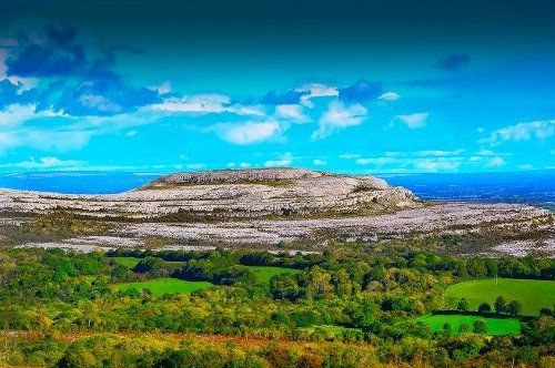
The photograph was taken by Shelly Wolf from L.A. He and his wife Barbara were
on a Burren tour with me on a golden autumn day – the very first day of October
2016.
We stopped at a lay-by in the townland of Fahee South about 5 km east of the
tiny village of Carran as this photo opportunity presented itself.
The camera itself is pointing even further eastwards.
I like the image a lot as it can be read as having at least four different frames.
ONE
The
lush green pastures in the foreground are in Glencolmcille (locally known as
”Glan”). The placename is an Anglicisation of Gleann Cholm Chille (the valley of
St Colmcille). The monastic site (now ruins) in the valley are dedicated to
this 6th century monk.
Like all Burren valleys, Glencolmcille has generous glacial deposits of sands,
clays and gravels overlying the porous limestone. It makes for excellent
terrain for pastoral farming. However, the valley would have been covered in
oak trees in prehistory. It was farming
communities in prehistoric/early historic times who converted the forest in to
the grasslands we see today.
TWO
The stony hill of Turloughmore is perched above Glencolmcille. The Burren
hills have been compared to a giant staircase with their classic terrace and
cliff topography.
Moreover, the rocky uplands in the region make for a strong contrast with the
lavish soil cover in the valleys below. The Turloughmore range extends for more
than 6 km. The highest point is 267
metres. The great mapmaker/landscape writer, Tim Robinson, records 7
prehistoric tombs along the range.
The Burren uplands are home to one of Europe’s most distinctive landscapes –
limestone pavement. In fact the region boasts the most extensive area of
limestone pavement in the European Union. So much of the bedrock in the hills
has been exposed due to glacial erosion and uber-enthusiastic prehistoric
agriculture. Thus, one could argue that the Burren uplands are in part a deeply
humanised landscape.
Hills like Turloughmore are still farmed today albeit in the autumn/winter
only. Cattle are transferred to the uplands for the period November to April.
This farming regime is highly unusual and is called reverse transhumance.
THREE
The white Derrybrien wind turbines are just about visible in the middle left of the image (behind Turloughmore). The
turbines are built on Slieve Aughty - a 25
km-long Old Red Sandstone hill range extending from east Clare into south east
Galway. It is a wild and desolate landscape of uplands bogs. (Bogs are wetlands
that accumulate peat, a deposit of dead plant material). The highest point on
the range is Maghera (400m).
The Derrybrien wind farm has 70 wind turbines and was one of the largest wind
farms in Europe when it was built in 2003. The farm, constructed by the
semi-state energy body E.S.B., precipitated a 0.5 million tonne peat slide with
significant environmental damage and a fish kill of 50,000. Bogs are
notoriously unstable environments. Construction of large-scale infrastructural
projects on bogs without proper environmental impact assessment can lead to
environmental chaos.
FOUR
The
final frame in the image is the “cloud formation” as Shelly phrased it. It was
a remarkably still, bright autumn day. The clouds were frozen on the canvas.
The 1st
of October was a day from heaven in Ireland and the month kept giving. Met
Eireann, the Irish Meteorological Service, summarised October as “extremely dry
almost everywhere” with “mean air temperatures on or above average nearly
everywhere”. However, November has returned to the form of most of 2016 – unsettled and
changeable. We will look back on October 2016 as mí na míosa
– the month of
months.
Shelly informs me that the shot was taken with a Nikon D5
camera and a 20mm Nikon lens.
Thanks to Shelly and Barbara for the company and the sublime photo.
Go n-eirigh an bóthar libh.
May the
road rise with you.