


The Placenames of the Burren
INTRODUCTION
Irish (or Gaelic) is one of the oldest living languages in Europe. It is a
Celtic language and part of the Indo-European family.Irish declined
dramatically as the majority language in Clare and Ireland in the 19th
century.The last
native Irish speaker in County Clare, the seanchaí
(storyteller) Paddy Pháraic Mhichíl, died in Doolin the
early 1990s.
Though dead as a
native language in Clare, Irish is still spoken in the Burren today as a second
language by a small minority of tenacious Irish language enthusiasts.
The Great Hunger of the 1840s saw the disappearance through death and
emigration of up to three million people – mostly native Irish speakers. In the
post-Famine period, a burgeoning Irish middle-class adopted the English
language as a means of advancing themselves within the British administration
in Ireland. Moreover, the same administration conducted a radical and often
brutal programme of linguistic colonisation, most notably through the National
Schools.
The 19th century linguistic imposition also involved family and place names being anglicised.
PLACE NAMES
The vast majority of the place names in Ireland today are thus quite
meaningless – having been mangled in translation as part of the enormous 19th
century British Ordnance Survey mapping of the country. One has invariably to
revert to the Irish language in order to understand the meanings of place names.
Toponymy (the study of place names) is important for a number of reasons. Place names assist communications throughout the world. They establish and reinforce identity. Moreover, place names can help greatly in our understanding of the history or geography of individual locales.
“THE BURREN” and “THE CLIFFS OF MOHER”
An excellent example of the anglicisation of a Gaelic place name is “the Burren”.
Many think that the name signifies a barren place. Not alone is the Burren not
a barren region but the name is in fact derived from the Irish An Bhoireann
, which signifies “a place
of rock”.
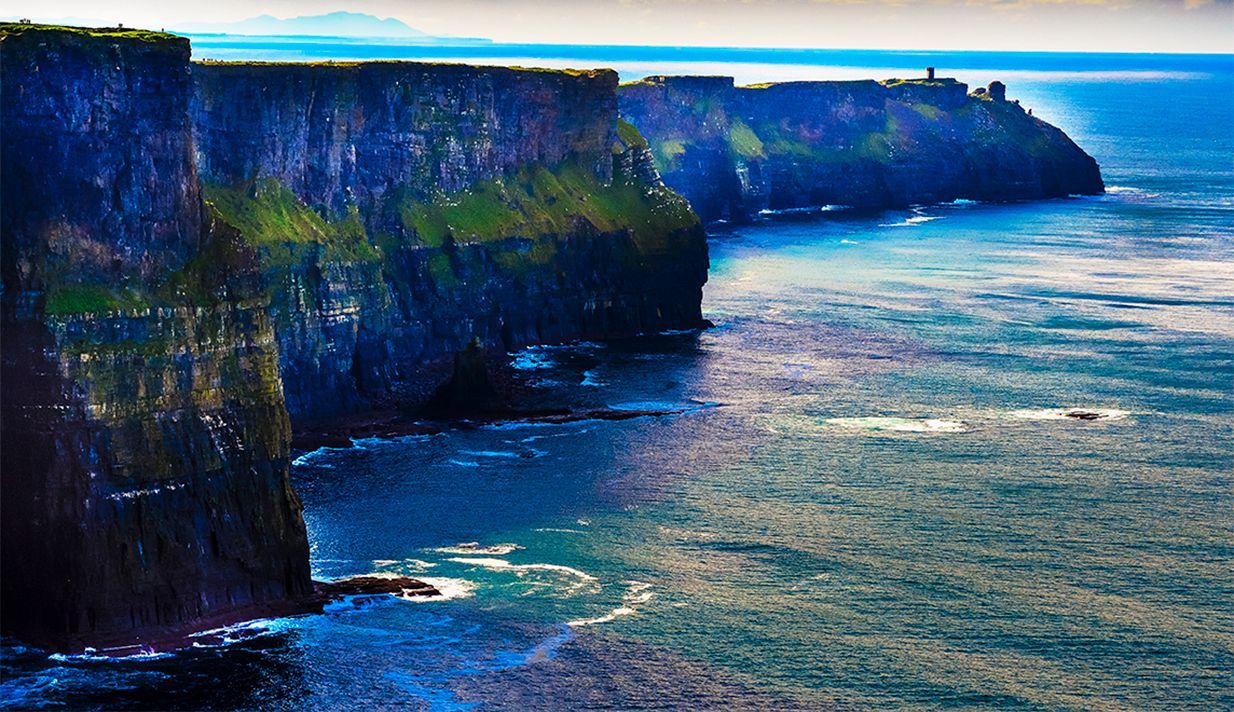
As for the Cliffs of Moher - the place name “moher” is a translation of mothar, meaning a ruin, in reference to a ruined prehistoric fort (no longer extant) at one of the most southerly points of the Cliffs . The Cliffs are primarily visited today for their outstanding natural beauty. However, the original placename informs us that the Cliffs were of strategic importance to a prehistoric élite.
THE VILLAGES
“Bally” is an extremely common prefix in placenames in Ireland. Bally derives
from baile
which originally meant human
settlement. Many “bally”-prefixed towns and villages in Ireland today were
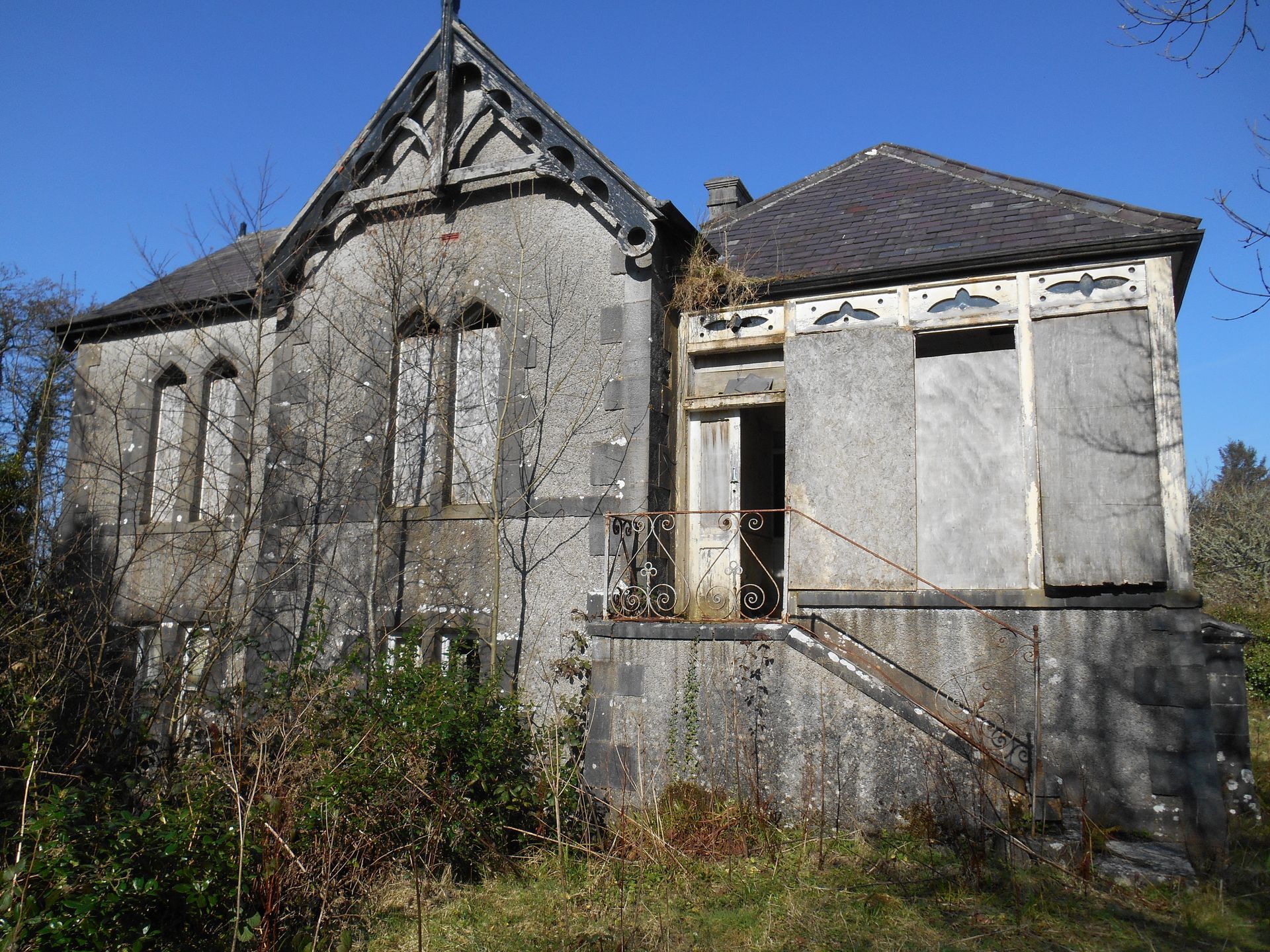
founded long after the place name was given. Ballyvaughan is a picturesque village
in the north-west of the Burren. The present village was only built up around
the harbour in the 1800s. However, the place name Baile Uí Bheacháin
significantly pre-dates the village of today. It
means settlement of the Ó Beacháins, a historical Gaelic élite.
“Kill” is another very common prefix in placenames. Whereas “bally” signifies secular settlement, “kill” means church or ecclesiastical settlement. Killinaboy is the location of the Burren National Park. Its original name in Irish, Cill Iníne Baoith, means “Foundation of the Saint Daughter of Baoith”, an Early Christian saint. The monastic site of Iníne Baoith is a very important cultural site in the village of Killinaboy today.
Kilfenora is just a few kilometres west of Killinaboy. The
village is renowned for its dense concentration of high crosses. Its
ecclesiastical importance is also reflected in its original name, Cill Fhionnúrach,
translated as “the
church of the white brow”.
A word in Irish can often have several meanings. For
example, the word lios
(anglicised to
“lis”) is very common in placenames and can mean any of the following 1. Enclosed ground of ancient dwelling 2.
Ring-fort. 3. Fairy mound.
The coastal village of Liscannor lies just five kilometres south of the Cliffs. The original name of the village is Lios Ceannúir . It translates as “the fort of Connor”. The Connors were a dominant clan in the vicinity once. Thus, the “lios” in this case means simply fort.
Lisdoonvarna ( Lios Dúin
Bhearna
) means “enclosure at the gapped fort”. The fort in question is
Lissateeaun which is located 2.5 kilometres to the
north-east of the town.
The original name, Lis
an tSidheán
, translates as “the fairy fort”. Thus, we
can surmise that the “lios” in the case of Lisdoonvarna means fairy fort. According to tradition, a fairy fort is a
fortification which was believed to be occupied by fairies.
Place names with the prefixes “kill”, “bally” and “lis” tell
us of the human history of the locale.
On the other hand, the coastal Burren villages of Fanore and
Bell Harbour were so named because of topographical peculiarities which they
enjoy.
Fanore is sometimes referred to as the longest village in
Ireland. Its large, sandy beach boasts lavish views of the Aran Islands and
Connemara. The Irish name, Fán Óir,
means
“golden slope” – in homage to the slanted beach with its gold-hued sand.
Bell Harbour is an English “standardisation” of the Gaelic Béal An Chloga. Béal an Chloga
translates as “the
bell-shaped mouth”, in honour of the tiny, round-shaped bay on which the
settlement was founded.
THE R48O/”MONUMENTS ROAD”
The R480 is a regional road running north-south through the
Burren interior. It was also historically one of the principal artery routes in
the region. There is a high concentration of spectacular archaeological
monuments roadside today. That is why some heritage enthusiasts know the R480
as the “monuments road”.
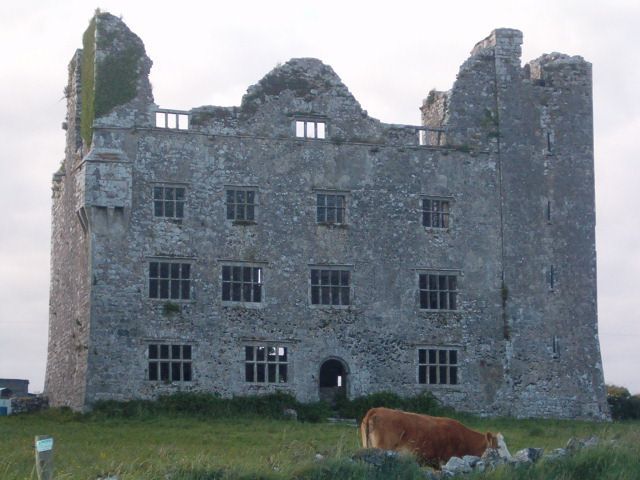
Leamaneh Castle is the first monument you meet when you progress north along the road. Leamaneh is a very impressive twin-structure of a Gaelic tower house and a successive “gentleman’s” mansion. Leamaneh derives from the Gaelic Léim an Fhia meaning “deer leap” in honour of the deer hunting tradition of the Gaelic aristocrats, the O’Briens. They inhabited the demesne in the Medieval period (late twelfth c. – early sixteenth century c. AD).
There are two roadside forts along the R480. They are Caherconnell (Cathair Chonaill) and Cahermore (Cathair Mhór). “Caher” is another very common placename prefix in Ireland. It originates from the Irish cathair, meaning circular stone fort. Cathair Chonaill translates as “Conall's stone ringfort" whereas Cathair Mhór signifies “big stone ring fort”.
The townland is the smallest geographical unit in Ireland.
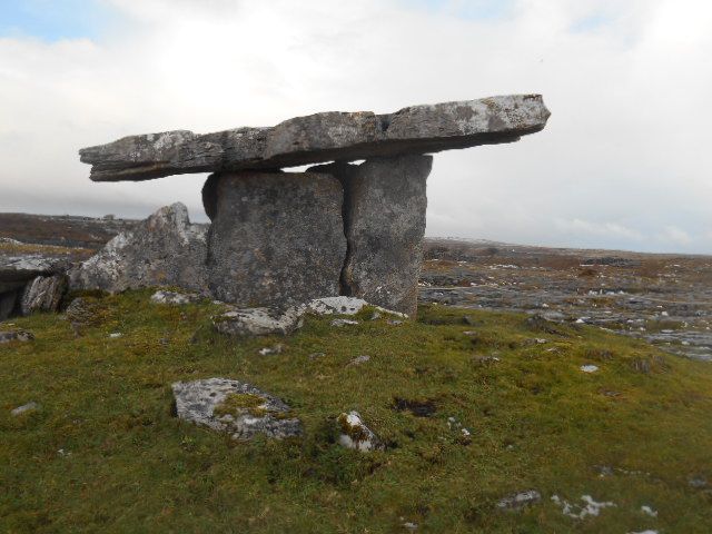
It is a colonial legacy just like the English language placenames. The most visited townland in the Burren is Poulnabrone,
home to the eponymous megalithic tomb. The spectacular funerary monument
attracts more than 200,000 visitors each year. The name Poulnabrone derives
from the Gaelic Poll Na mBrón
which
means “the hollow of the millstone”.

BURREN NATIONAL PARK
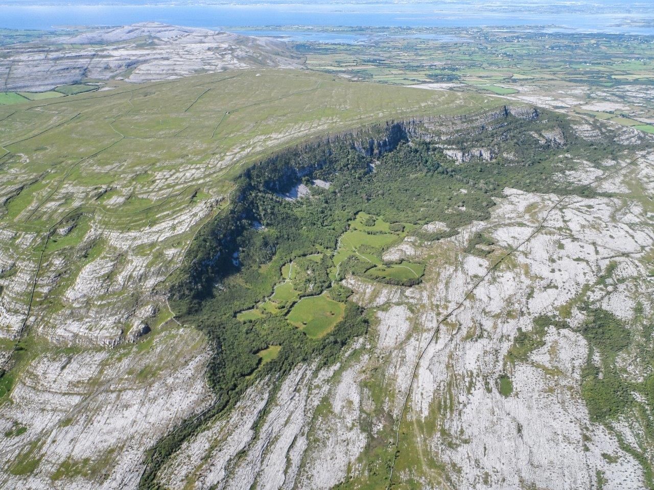
The Burren National Park is one of seven in the Republic of Ireland. The icon of
the Park is one of Ireland’s most eccentrically-shaped hills, Mullaghmore ( Mullach M
ór).
Mullach Mór (206m)
translates as “the big summit”. The word “mór” means big and it is common
enough in Irish placenames.The Carran part of the National Park is located at the base of Slieve Carran ( Sliabh Cairn). Slieve
is a common prefix
in place names and signifies hill. So ”Sliabh Cairn” translates as the Hill of
the Cairn in honour of a prehistoric tomb on its summit.

Ireland
is one of the most minutely-detailed landscapes in Europe. Almost every field
has a name and even features within fields on occasion are place-named. Two
very good examples from this vast heritage of microtoponymy in Ireland are Léim
an Phúca
Mór (Big Fairy's
Leap) and Léim an Phúca
Beag (Small Fairy's
Leap). They are two gaps in the summit of Turloughmore hill in the National
Park, located opposite Slieve Carran.
The Púca is a fairy, a spirit horse. Whist he features on occasion in placenames in the Burren, surviving
folk tales regarding him are scant. Belief in fairies was widespread in
pre-Famine Ireland. The post-Famine period was marked by a huge decline in
vernacular culture including folk beliefs.
TOLKIEN
The Burren
underworld is the most extensive in Ireland and the discovered caves have been
place named. Pollnagollum ( Poll na gColm
)
is the longest cave on the island
of Ireland. It
is translated as “the cave of the doves”.
According to tradition, doves were wont to take refuge in the cave.
As it happens, Gollum is also the name of one of J.R.R. Tolkien’s best-known
characters. Some “Burrenarians” (Burren enthusiasts) maintain that the author’s
middle-earth was inspired by the eccentric Burren landscape. Tolkien was a
frequent visitor to the region.
CONCLUSION
Directional road signs in the Republic of Ireland are
bilingual. This linguistic parity is thanks to a constitutional imperative.
When you are travelling through the Burren and beyond, enjoy trying to decipher
the original Gaelic names. A valuable resource in this regard is the place name
website www.logainm.ie
Finally, bain suaimhneas agus sonas as Boireann na gcarraig . Enjoy the rocky Burren!