Tobar Iníon Baoith, Commons South, Killinaboy
THE SAINT
Iníon Baoith is a localised female saint whose cult is mostly found in mid-Clare. The eminent local historian, Michael Mc Mahon, has identified at least 17 holy wells, with a mid-Clare geographical bias), dedicated to Iníon Baoith in the Ordnance Survey name books from the 1840s. The wells are located at Killinaboy, Kilnamona, Glensleade, Kilshanny, Kilmanaheen, Inchicronan (Crusheen), Doora, Quin, Kiltcaky More and Quakerstown. (Mc Mahon ; 2013).
KIltacky More and Quakerstown are townlands on the border between Counties Clare and Galway. Both wells are now known locally as St Colman Mac Duagh wells despite the official Iníon Baoith dedications. This would suggest that at some stage the Iníon Baoith cult weakened as it neared the border with south-east Galway.
Killinaboy parish is home to highest number of Iníon Baoith holy wells (4). Other Iníon Baoith dedications in the parish include the medieval church, Suíochán Iníon Bhaoith (a stone seat with healing powers) and the Tau cross (formerly known as the cross of Iníon Baoith). The plethora of dedications would suggest that the cult of the saint was strongest in Kilinaboy parish area. All of the Iníon Baoith sites were the focus of ritual in the past.
Saint Iníon Baoith's origins are most unchristian as her cult seems to have migrated from the south Limerick/North Cork area with a 1st millenium A.D. tribe.
It is interesting that a couple of of Inion Baoith dedications do in fact survive in the south Limerick/north Cork region.
The Cork dedication can be found at a holy well in Dromtarriff, a few kilometres south of Banteer. The Limerick evidence of the Inion Baoith cult can be found in the Glenmore in the parish of Killeedy as Glenmore's former name was Killinewee. (Killinewee is an anglicisation of the the Gaelic Cill Iníon Baoith, the Church of Iníon Baoith). (O'Riain ; 2011).
Christianity arrived in Ireland in the 5th century. At some stage during this religious revolution, the pagan idol of Iníon Baoith was re-invented as a Christian saint in a process known as syncretism....a process whereby some pagan custom and idols were incorporated into Christianity. This pragmatic approach by the Christians ensured that their revolution was not only successful but peaceful also.
There are over 1000 entries in Pádraig O Riain's de profundis
"A Dictionary of Irish Saints". Female saints are very much in the minority in the publication which spans the Early Medieval period (c.400 to late 12th century A.D.) in Ireland. Saintesses of greater renown than Iníon Baoith include St Brigid of Kildare, St Ita of Killeedy County Limerick and St Gobnait of Ballyvourney Co Cork. This "triumvirate" are credited with founding nunneries. (Condit and Cooney ; 2007). It is also indeed highly plausible that there was a nunnery dedicated to Iníon Baoith at the Killinaboy monastic site.
Iníon Baoith's cult waned significantly in the 19th century. Visitation of her cult sites in the parish declined. The practice of christening girls with the name Innerwee also faded in the 1800s. (Curry ; 1839).
Moreover, both the 19th and 20th century churches in the parish have eschewed the Iníon Baoith dedication.
Bibliography -
The Parish of Corofin A Historical Profile
by Michael Mc Mahon. Michael Mc Mahon (2013).
A Dictionary of Irish Saints
by Pádraig O'Riain. Four Courts Press. (2011).
The Other Monasticism
by Tom Condit and Gabriel Cooney. Archaeology Ireland Heritage Guide No. 38. Wordwell Books. (2007).
The Antiquities of County Clare. Ordnance Survey Letters 1839
by John O'Donovanand Eugene Curry. Clasp Press. (1997).
LANDSCAPE CONTEXT
The Early Medieval monastic site of Iníon Baoith consisted of 811 plantation acres. (The Irish acre or plantation acre is a measurement in disuse now. It approximates to 1.62 statute acres or 0.66 hectares). The monastery tenants also had access to another 900 acres of 'rocky pasture' for their common use. This approximates to what we know today as the townlands of Commons North & Commons South, though some small portions of other townlands were also included. Of the Commons, only about 40 acres were considered profitable. (Mc Mahon ; 2017).
Thus Tobar Iníon Baoith, which is located on the rocky pasture of Commons South, is situated within the monastic termon of Iníon Baoith. Moreover, there are two other holy wells in Commons South within the termon. They are the second well named after the saint, Tobar Iníon Baoith, and also Tobar Bhaighdeán.
Holy wells are often located near the ruins of medieval churches (or on the sides of hills or mountains or by the seashore) (O’Sullivan and Downey ; 2006).
Bibliography -
Know Your Monuments Holy Wells by Muiris O'Sullivan and Liam Downey. Archaeology Ireland. (Spring 2006).
Buiochas le.../Thanks to...
Michael Mc Mahon for the information on the area of the Early Medieval monastic site of Iníon Baoith.
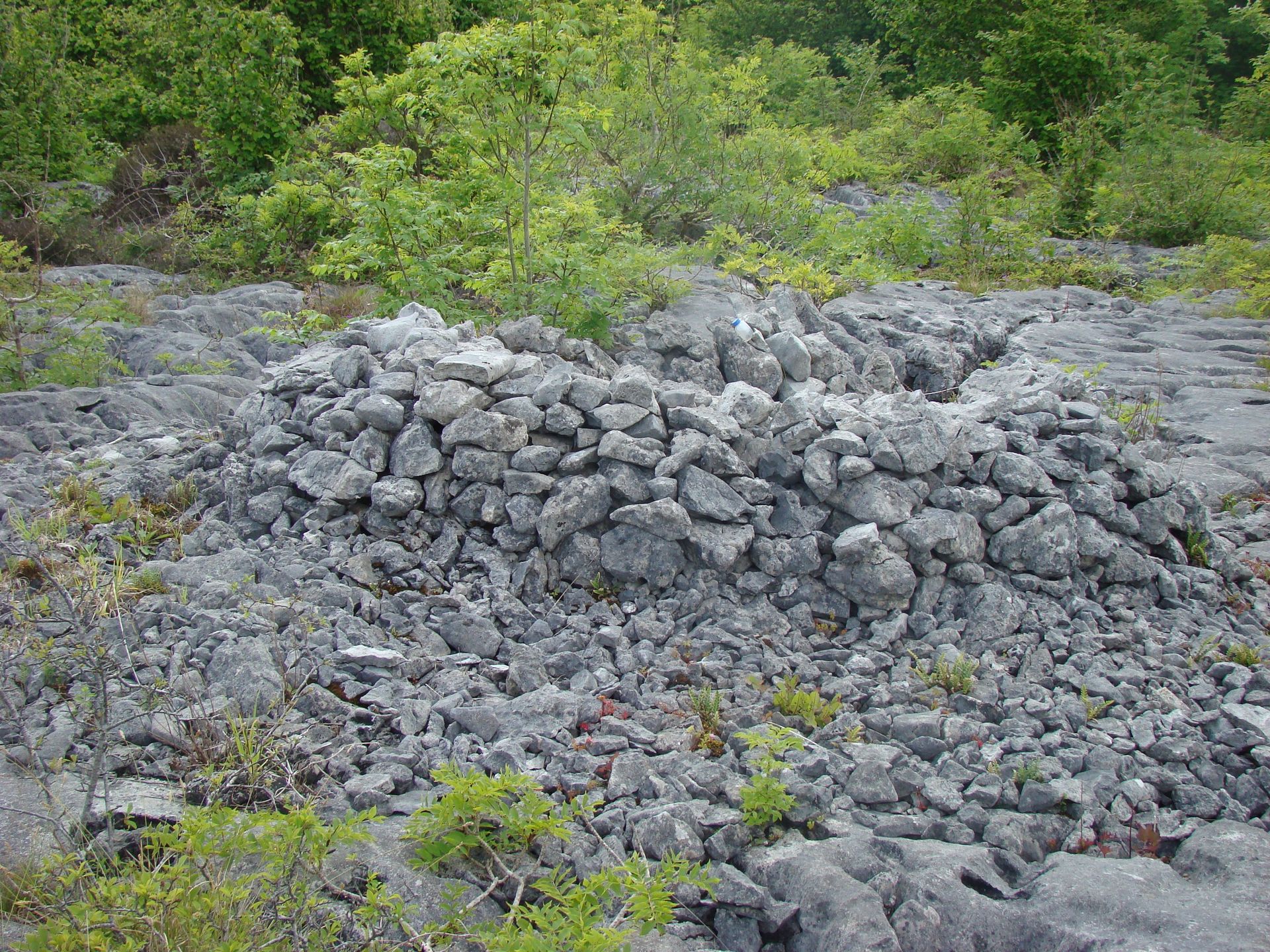
THE WELL HOUSE
The house is an elliptically-shaped dry stone construction enclosing the well. It is 2.8 m long and measures 2.5 m at its widest point. Access to the well is by an aperture in the house which is 0.45 m wide.
The house is single stone-width (0.45 m approx) except for the rear wall which has a depth of up to 1.3m of stone. The altar is flat piece of stone (0.4m by 0.2m) which is known locally as "the flag". The flag is inserted in to the interior of the rear wall. It overhangs the well at a height of 0.29 m above the ground.
The flag serves to denote the sanctity of the space but also acts a repository for devotees' offerings.
There is a small depression in the pavement under the flag and just behind the well water.
This naturally occurring feature has been re-invented by devotees as another point of deposition of the offerings or "devotionalia".
THE OFFERINGS
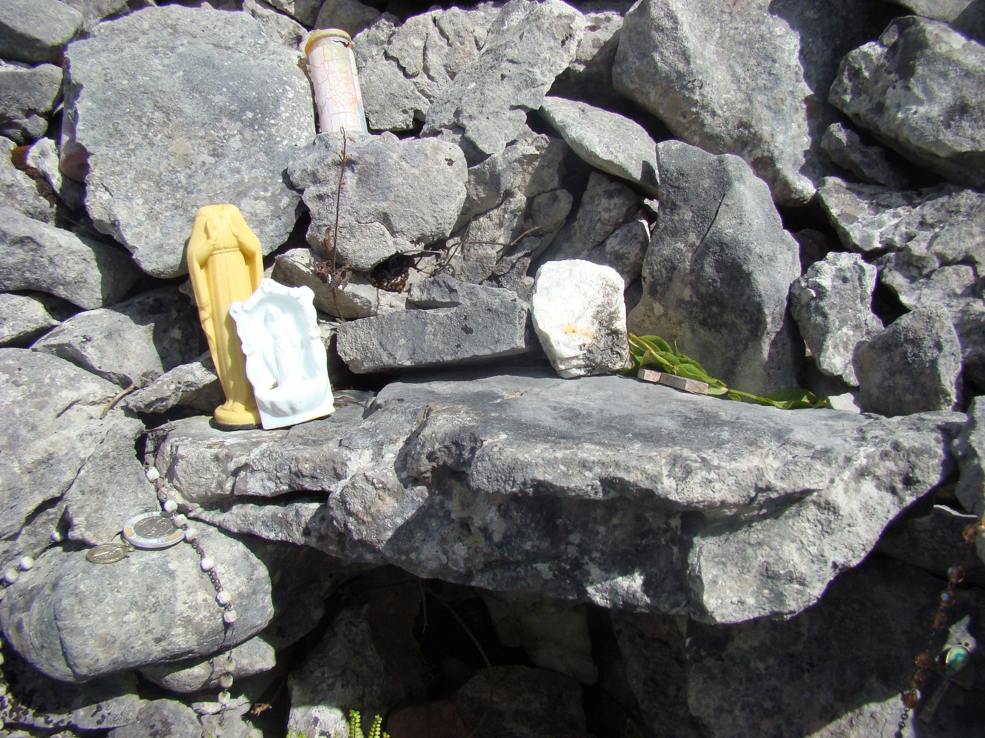
Site visited 7th February 2017.
There were a medallion and 4 religious figurines on the altar.The following offerings were recorded in the small depression in the
pavement behind the well - approximately 90 coins in the new currency.
Two small pieces of limestone. 2 other small stones – one red in colour, the
other grey.
These latter stones are from geological areas other than the Burren and were
deposited as offerings probably because of their exotic look.
Two secular tokens - a plastic bottle top and an ear ring.
The following religious tokens - the Madonna in a grotto ; a wooden crucifix ;
2 metal crucifixes ; 6 religious medals ; a headless figure of Mary ; a photo
of the holy family Jesus, Mary and Joseph.
There were 20 coins clustered on the ground a few centimetres from the well.
Finally, one small piece of granite was recorded in the interior wall of the well house.
THE HYDROLOGY OF THE WELL
The
well is a natural solutional hollow in the limestone. There are many similar
features in the surrounding pavement.
The hollow is fed by rainwater draining from the surrounding pavement at
shallow depth (920-30cm). This is known as epikarst drainage and it is quite
common in the Burren karst.
The water drains horizontally and fills the hollow up to a depth of 15cm before
overflowing. Thus there is a mini-pool just below the surface with no outlet.
Even with no inflow in dry weather, the water would take a month or two to
evaporate altogether. As it never goes that long without rain in the region,
the mini-pool never dries up.
Killinaboy parish is mostly agricultural and that is why floods and even
droughts are keenly noticed as they both have a negative impact upon the
pasture. The stability of the water supply in the well was a source of local
fascination in the past and is still the subject of some comment today.
"And no matter how dry the weather is or how wet, the well would not get
bigger or smaller" (Teller John Costelloe, Coad ; collector Joseph
Costello 1937/38).
"It never increases or decreases after the biggest flow or the greatest
drought" (Teller George Pilkington, Leamaneh ; collector Seán Pilkington ;
1937/38).
THE PERSONALITY OF THE WELL
There are a number of similar solutions in the surrounding area which begs the question as to why the water from this particular hollow was ordained to be "blessed".
Holy wells, known to cure for eye ailments, may on occasion resemble an eye (Janet Bord ; 2006).
Another example in the region of an eye-shaped holy well is St Colmcille's at Crumlin in Fanore. The well consists of two solutional hollows resembling a pair of eyes and St Colmcille's is also renowned for eye cures. The natural likeness of the well to an eye helps to endorse it as a supernatural antidote to eye ailments.
Moreover, David Drew points out another peculiarity about the well - Even with no inflow in dry weather the water would take a month or two to evaporate dry. As it never goes that long in County Clare without rain, the well never dries up.
This characteristic was the subject of comment and wonder locally in the past (John Costelloe and Seán Pilkington ; 1937/38) and still is to a limited extent today.
"And no matter how dry the weather is or how wet, the well would not get bigger or smaller" (Teller John Costelloe, Coad ; collector Joseph Costello 1937/38).
"It never increases or decreases after the biggest flow or the greatest drought" (Teller George Pilkington, Leamaneh ; collector Seán Pilkington ; 1937/38).
Thus the constancy of the water also helps explain why the well is the subject of veneration.
Finally, another peculiar trait ascribed to Tobar Inion Baoith was that its water could not be boiled (John Costelloe ; 1937/38). We are obviously in the realm of folk belief here rather than science. This non-boiling belief was common regarding the water of many holy wells and served to distinguish the blessed (abnormal) water from the secular and prosaic domestic water. The latter would always behave "normally" when one tried to boil it.
THE CURE
The well water is known to cure two ailments - warts and sore eyes (Mrs Hawes, Kilnaboy ; 1937/38). Most holy wells are known to cure just one affliction. However, 4 of the 9 holy wells in Kilnaboy were renowned for both eye and wart cures. The other two "twin cure" wells are Tobar Bhaighdeán in Commons South also, Bullán Phádraig in Poulnalour and St Anthony's in Caherblonick (no longer extant).
A wart is an infection to a top layer of skin which causes the growth of cells. This growth of cells creates the wart. The portal for the infection is often cut skin. Good hygiene helps to stop warts developing in the first place. When contracted, the warts can be counteracted by tending to the cut skin.
However, life in rural Ireland in recent centuries featured tough manual labour and poor hygiene conditions for the huge numbers of destitute. Poor people were often dirty and were unable to heat water in the 18th and 19th centuries (Liz Curtis ; 1994).
The fact that 4 of the 9 wells in the parish were renowned for curing warts, (as well as eye ailments), would suggest that warts were a widespread affliction in the past.
There is one other Inion Baoith well in North Clare formerly resorted to for the wart cure. It is known as Toberinneenboy (an anglicisation of Tobar Iníon Baoith). The well is located in Glensleade in Kilcorney parish north-east of Kilnaboy.
The writer and map maker Tim Robinson shared an amusing story with me related to this latter well. During the course of Robinson's field work in the Glenseade townland for his 1999 Burren map, a local elder told him of an incident at the well when he was young - two local boys robbed some of the coins which had been left as offerings at Toberineenboy. The next day the lads were both afflicted with warts.
It would appear that not only were devotees obliged to leave an offering as part of the well ritual, but also on no account should anyone remove the offerings of devotees.
Though wart wells were numerous, the most widespread holy well type was the eye-well.
All 9 holy wells in Killinaboy were resorted to for cures for eye ailments. Moreover, a very disproportionate number of holy wells in the national context in Ireland are eye-wells. The international situation seems to mirror that of Ireland.
The treatment of eye ailments seems to be the most recorded attribute of holy wells (Varner ; 2009).
Gary Varner ascribes the eye-well predominance to Vitmain A deficiency in the diet of the "commoners". The deficiency causes xeropthalmia or dry eyes. If the condition is left untreated, it causes ulceration and ultimately blindness. A poor diet (or lack of dietary diversity) was certainly the lot of the rural poor in pre-Great Famine Ireland surviving as they did on a diet of potatoes and a liquid accompaniment. The potato had been introduced into Ireland in the 16th century. However, it began to play a dominant role in the diet before the end of the 17th century.The rural poor accounted for more than 80% of County Clare's population at the start of the 1840s - the decade of the Great Famine. (Mc Mahon : 2010).
The housing conditions of the rural poor in Ireland were very unhealthy prior to the Famine. According to the 1841 Census, over 85% of the houses in the Burren parishes were fourth-class, defined as single-roomed mud dwellings. (Smyth ; 2012). A minority of these houses had chimneys and fewer still had effective chimneys . The smoky interior was a cause of eyesight deterioration and also helps explain why there is such a dense concentration of eye-wells in the countryside.
The terror induced by the thought of failing eye sight or blindness may also explain why eye-wells comfortably outnumber wells renowned for such as back, tooth and wart cures. The demand was reflected in the supply.
Finally, apart from "aquatherapy", a number of other types of unofficial medicine, including herbalism, were resorted to in the past by the rural poor in order to treat ailments. For example eyebright has been recorded in Killinaboy as a plant resorted to by some in order to treat eye maladies. "A herb called eye bright can cure sore eyes by rubbing it to the eye three times." (Teller - Mícheál O Cuinn, Coad ; Collector - Áine Ní Chuinn, Coad ; 1937/38).
Bibliography -
The Cause of Ireland by Liz Curtis. Beyond the Pale Publications. (1994).
Sacred Wells A Study in the History, Meaning, and Mythology of Holy Wells and Waters by Gary R. Varner. Algora Publishing. (2009).
The Rural Poor in Clare before the Great Famine by Anne Mc Mahon. From The Other Clare. (2010).
Atlas of the Great Irish Famine . Edited by John Crowley, William J. Smyth and Mike Murphy. Cork University Press. (2012)
Wiilim J. Smyth p.187.
The Schools' Collection (National Folklore Collection of Ireland ; 1937/38).
THE RITUAL
In order to get the cure, the well must be visited on two Mondays and a Thursday (Mrs Hawes Kilnaboy ; 1937/38).
As at all holy wells, prayers are recited as the devotee walks around the monument in a sun-wise fashion, known in Gaelic as deiseal. If one wishes to invoke a malediction against somebody, one prays and walks in an anti-clockwise fashion (tuathail). In the case of Tobar Iníon Baoith, the prayers invoked are one Our Father and three Hail Marys (Mrs Hawes, Kilnaboy ; 1937/38).
On completing the rounds, the devotee must leave a blessed offering (Mrs Hawes, Kilnaboy ; 1937/38).
Finally, the well water at Tobar Iníon Baoith must be rubbed "to the eye or the wart" (Mrs Hawes ; 1937/38). At other sites, the custom is that the water must be drunk....and in more cases again, the water is also carried away largely for the benefit of devotees who are unable to reach the site. Question 10 of National Folklore Collection questionnaire is quite instructive in this regard as it asks "is the water applied to the afflicted part? Is it drunk? Is it also carried away?"
In the case of Tobar Mogua in Noughaval (eye cure), water was drawn from the well on occasion up to the 1960s and conveyed to Australia to exiled Noughaval parishioners so that they could access the magic drop. (Source - local elder).
LIST OF the 9 HOLY WELLS IN the PARISH OF KILLINABOY and THEIR CURES
Tobar Iníon Baoith, Commons South. Eyes and warts.
Tobar Bhaighdeáin (The Maiden’s Well), Commons
South. Eyes and warts.
Bullán Phádraig (St Patrick’s Well), Poulnalour. Eyes and warts.
St Anthony’s, Caherblonick (no longer extant). Eyes and warts.
Tobar Inion Baoith, Anneville. Eyes.
Tobar Iníon Baoith, Ballard. Eyes.
Tobar Iníon Baoith, Commons South. Eyes.
Tobar Mháirtín (St Martin’s Well), Leamaneh. Eyes.
Tobar Duibh (The Black Well), Caherfadda. Eyes and swollen limbs.