Blog Post

A Secret of the Burren landscape

  • By tony kirby
  • 17 Feb, 2016

A Holy Well on the R480

A religious figurine - an offering on the altar above Tobargahard holy well.

The R480 is a 16.4 kilometre long regional road stretching from Ballyvaughan in the north of the Burren to Leamaneh Castle in the south.

It is the main arterial route in the Burren interior. In high season the road can be heavily trafficked.

The roadside is littered with outstanding National Monuments including the ring forts An Ráth, Cahermore and Caherconnell. Ireland’s oldest known megalithic tomb Poulnabrone (5,800 years old) is also on the verge of the road. Poulnabrone attracts at least 100,000 visitors per annum.

 I recently “discovered” another monument along the road – a holy well called Tobargahard. It is a magical site which seems to avoid the attention of almost everybody.

Tobargahard was formerly situated in the classic Burren upland landscape of limestone pavement and thin soil. However, the monument has been hidden in recent years by the advance of hazel scrub. Scrub is advancing due to decline in farming in the uplands. The scrub may eventually occlude the well entirely from future generations. Hazel is glorious native tree but it is an enemy of archaeology.

 Tobargahard may be an Anglicisation of Tobar go hArd which means the well on high. The monument is located just above Gragan Valley which was heavily populated in the 19th century. There is a walled entrance to the well which faces the valley. The wall is now covered in moss which is thriving in the scrub. 

Folk medicine was widespread in the past and the belief was that the Tobargahard water cured eye ailments. I reckon that the waters of about 50% of Ireland’s 3,000 plus recorded holy wells are renowned for eye cures.

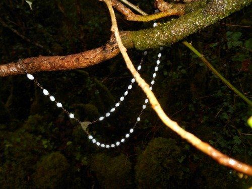
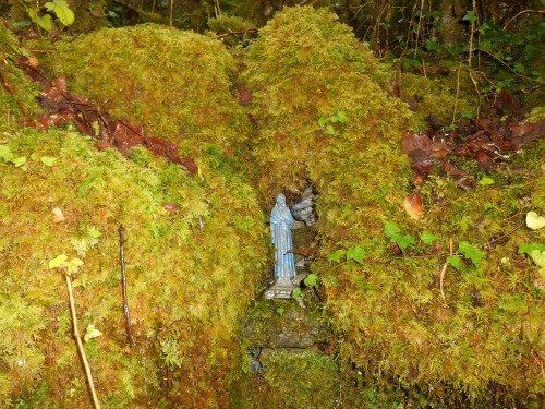
 I recorded just three pilgrim offerings at the site - two religious figurines on the altar above the well and a rosary beads hung from a tree. When the wind blows, the beads swing like a pendulum.

Tobargahard is an almost abandoned sacred site, a secret of the Burren landscape, a haven of tranquility.

Rosary beads left by a pilgrim as an offering. Hanging on a hazel tree beside the holy well.
By tony kirby 22 Mar, 2024

INTRODUCTION
Irish (or Gaelic) is one of the oldest living languages in Europe. It is a Celtic language and part of the Indo-European family.Irish declined dramatically as the majority language in Clare and Ireland in the 19th century.The last native Irish speaker in County Clare, the seanchaí (storyteller) Paddy Pháraic Mhichíl, died in Doolin the early 1990s.

Though dead as a native language in Clare, Irish is still spoken in the Burren today as a second language by a small minority of tenacious Irish language enthusiasts.

The Great Hunger of the 1840s saw the disappearance through death and emigration of up to three million people – mostly native Irish speakers. In the post-Famine period, a burgeoning Irish middle-class adopted the English language as a means of advancing themselves within the British administration in Ireland. Moreover, the same administration conducted a radical and often brutal programme of linguistic colonisation, most notably through the National Schools.

The 19th century linguistic imposition also involved family and place names being anglicised.

By tony kirby 07 Feb, 2022
INTRODUCTION
The placename Glencolmcille comes from the Irish Gleann Cholm Cille  meaning the valley of St Colmcille. Glencolmcille is today a sparsely-populated, fertile valley 5.5 kilometres east of Carran, the only village in the Burren hills. An ancient pass ran through the valley in the past providing a critical link between the Burren region and the outside world to the east of it. The importance of this routeway is reflected in the location of many signature sites along it, including four castles in Glencolmcille itself along with an ecclesiastical site of Early Medieval (431-1169) origin. According to tradition, the latter was founded by the renowned monk, Colmcille. The ruin of a church and a graveyard (still in use) stand today on the former ecclesiastical site. The church is considered to date from the 12th century.
By info@heartofburrenwalks.com 24 Feb, 2021

Saintesses like Ita, Brigid and Gobnait are in and around Imbolg but Iníon Baoith is an outlier on the calendar. Her patron day is December 29th - round about the winter solstice.

Her cult is strongest in Killinaboy in Clare where amongst other monuments, there are four holy wells dedicated to her.

Toberineenboy (Tobar Inion Baoith) is on commonage in Commons South and is renowned for cure for sore eyes or warts.

By info@heartofburrenwalks.com 28 Jan, 2021

‘Tobar Chornáin, near Black Head.
Perhaps the most decorative of the many wells, holy or otherwise, which dot the Burren’.
Peadar O’Dowd.

Tobercornan was a natural spring before it was ‘welled’.
One presumes it was welled when it was canopied.

That happened circa 1860 and so thereafter Gleninagh North had two canopied wells.
The other well is Tobernacrohaneeve, Tobar Na Chroíche Naoimh, only one km away.
Is Gleninagh North the only townland in all of County Clare with, not one, but two canopied wells?

Officially known as Tobercornan, Tobar Chornáin. Now commonly known as the Pinnacle Well.
Discounted by some as not being holy historically though Cooke did state in the 1840s  that ‘The neighbouring peasantry call it a Blessed Well.’

The Tobercornan well house was probably commissioned by the land lord, Bagot Blood. Extravagant and all as the design is, it can hardly be defined as a folly as it did serve a function, i.e., shelter for the water users.
By info@heartofburrenwalks.com 22 Jan, 2021
Il Blu Depinto di Blu,  in the blue painted in blue, in the Burren National Park at the turning of the year 2020. Air temperature was no more than 4 degrees Celsius. A north wind is blowing Arctic air down on us - a phenomenon known locally as 'The Black Wind'.

The location is Creehaun (Killinaboy), one of 64,000 plus townlands in Ireland. Creehaun measures almost 270 hectares and it does not have a single inhabitant. The place name is a mangling of Crítheán , a bushy place

The big water body is a dramatic winter merger of three lakes - Loch Sceach Ard (high bush lake), Loch Trá Bhán (white strand lake) and Loch Cúil Úrta (damp wood lake).

The three most easterly peaks beyond the water make up the Turloughmore range - a seldom-trod part of the National Park. The heights are 200m, 224m and 267m.

Stone, water, uplands... but the star of the show is the 'candy floss' - cumulus fractus.

Fractus clouds have this jagged, shredded appearance as they are seared by strong winds. They are indicators of fair weather and do not contain precipitation. (Thanks to Nick Geh for the identification). 

Il Blu Depinto di Blu is the title of a song more commonly known as 'Volare' written by Domenico Modugno and released in 1958. Domenico died in 1994 but his song has not ended.  A presto!
By info@heartofburrenwalks.com 24 Dec, 2020

The less well known of the two St Flannan's Wells in Inagh, County Clare. Flannan being the patron saint of the parish of Inagh. Flannan's day is over - just. It falls on December 18th. "If a person went on the eighteenth of December he would not have to go anymore." (Schools Collection Vol 0611 p. 109).

The well is in a remote location now in Muckinish. It was not always thus. Once the well was located along the old bog road between Ennistymon and Inagh.

By info@heartofburrenwalks.com 06 Jul, 2020

A reptile is a cold-blooded vertebrate animal that includes snakes, lizards, crocodiles, turtles and tortoises. We have one native reptile in Ireland and it is the viviparous lizard (Lacerta vivipara). Earc luachra is the Irish for the creature. A viviparous animal is one which brings forth its young live (as opposed to in egg form).

The viviparous lizard is the most northerly reptile in the world and can even be found within the Arctic Circle. It averages 10 to 16 cm in length. It suns itself in order to reach a body temperature of 30 degrees C. It is then able to hunt effectively. Diet is small insects.

The lizard's predators include kestrels, stoats and minks. If the predator grasps the lizard by the tail, the lizard divests itself of the tail piece leaving the aggressor with a stump. The lizard then grows back its tail.

In the pre-antibiotic era in Ireland, folk medicine was widely practised across the country. The medicine was a mix of the natural (cures from herbs, plants, minerals and animal substances of nature) and the magico-religious. The latter consisted of magic, religious/holy wells and healers (Barron Soverino 2018, 1)

One of the folk beliefs was that if a person licked a lizard, he/she could cure a person of a burn by licking it. There are a number of references to this cure in the Schools Collection for schools in North Clare (SC  Vol 0614, 321, Killinaboy ; Vol 0615, 307, Rathbaun ; Vol 0616, 049, Aill Bhéil an Tulaigh/ Ballyvaughan (Drumcreehy)). The Schools Collection is  a collection of folklore compiled by schoolchildren in Ireland in the 1930s.

The accompanying photo was taken in Ballyryan in the south-west of the Burren.

According to propaganda, Saint Patrick is credited with banishing snakes from Ireland. Tellingly, Patrick himself never made such a claim in his epistles. Snakes never reached Ireland. The snakes in the Patrick legend are a symbol of paganism.

Finally, there is actually one other reptile in Ireland. However, it is not native. It is the slow worm (Anguis fragilis). It is a legless lizard. Its range is confined to County Clare. The worm was introduced from another jurisdiction by misguided folk a couple of decades ago. As they say in Yorkshire - there's nowt as queer as folk.

Bí slán, sabháilte - Be safe and sound.

REFERENCES 
Barron, C. and T. Soverino 2018.  Put a frog in your mouth ; toothache 'cures' from Nineteenth- and Twentieth -century Ireland.  Journal of the History of Dentistry Vol  66, No.1.
National Folklore Collection  1937/38.  The Schools Collection.

By info@heartofburrenwalks.com 16 Apr, 2020

LOCATION
The well is located in a small cliff face in the townland of Rossalia on the north eastern slope of Abbey hill. It is 4 kilometres south east of New Quay and 11 kilometres west of Kinvara, Co Galway. An impermeable chert-rich zone on the limestone slope has caused a small outflow of water. The initial part of the outflow was walled in with a well house and is known as Tobar Phádraig (St Patrick’s Well).

An old, unsurfaced road (known as a “green road”) lies just below the well. Less than one kilometre to the east of the well, the green road links up with an ancient North Clare route way i.e. Carcair na gCléireach (literally the Clerics’ Slope), commonly known as the Corker Pass. This route from north Clare into south Galway dates back to the 16th century at least (Gosling 1991, 126). Thus, St Patrick’s has enjoyed a strategic location for centuries at least.

Furthermore, holy wells are often site-specific for symbolic reasons. Some are located on the sea shore (O’Sullivan/Dowling 2006, 37). Though St Patrick’s is not on the seashore, its expansive sea views means that the well enjoys a liminal land/water, world/otherworld location.  
BIBLIOGRAPHY
Gosling, P. (2001). The Burren in Medieval Times. The Book of the Burren . 2nd edition. Kinvara ; Tír Eolas.
O’Sullivan M. Downey L. (2006). Know Your Monuments Holy Wells. Archaeology Ireland. Spring Edition. Dublin Wordwell Books.

By info@heartofburrenwalks.com 26 Mar, 2020
INTRODUCTION
I had thought that the nearest County Clare had to an inhabited Atlantic island was Inis Oírr. It is known affectionately on occasion as "the Clare Aran" on account of it strong historical links with Clare. However, Inis Oírr enjoys stronger links with the Galway mainland today and is administratively part of County Galway. Inis Oírr is like its sister islands, Inis Meáin and Inis Mór, a Galway island.

Nonetheless, it did dawn on me quite recently that Clare does in fact have its own inhabited Atlantic island. It is Aughinish in the extreme north-west of the county. Some argue that Aughinish was only an island for a brief period from its detachment from the mainland in the 1750s to its re-attachment via a causeway in the early 1800s.

However, since Aughinish was "islanded" by a natural event (a tsunami) and "de-islanded" by a man-made structure (a causeway),  it is still technically and resolutely an island .  Aughinish enjoys its deserved place amongst the 570 islands documented in the encylopedic Irish islands guide Oileáin by David Walsh (2004, Pesda Press).

THE STORY OF AUGHINISH

Aughinish is a townland located in the very north of County Clare on the southern shores of Galway Bay. It is separated from the rest of Clare by water. Aughinish is peculiar in that it is only accessible by land via the neighbouring county of Galway. It is a small reality - only about 3 kilometres long and 1.6 kms wide.  

The place name is an English language mangling of the Gaelic Eachinis . Eachinis translates as Horse Island. "Ock-in-ish" is how the locals pronounce the name.


Aughinish was originally connected to County Clare. However, that connection was lost in 1755 due to the tsunami effect of the enormous Lisbon earthquake. The Great Lisbon Earthquake may have caused the deaths of up to 50,000 people. Its shocks were felt as far south as North Africa and as far north-west as the west coast of Ireland.
Subsequently, the British built the 0.80 km causeway from Aughinish to the County Galway mainland in order to service their troops in the martello tower constructed on the island after 1811.

Martello towers are circular coastal fortifications which the British built along the Irish coastline (and the coastline of the south east of England) in the early years of the 19th century as they feared a Napoeonic invasion of the then United Kingdom of Great Britain and Ireland. Aughinish's modern history has thus been literally shaped by two great European events - the 18th century Lisbon earthquake and poor Anglo-French relations at the turn of the 18th and 19th centuries.

Despite the causeway, Aughinish has an island-like feel to it.......a place apart with only about 50 inhabitants. The  population was more than 300 people prior to the Great Hunger of 1845-49 (Swinfen 1992, 7).

Aughinish's remoteness means that only the most intrepid visitor will seek it out. A visit is more than worth it as the island is not only rich in history and heritage but it also enjoys a beautiful coastal location. 

BIBLIOGRAPHY
Swinfen, A. (1992). Forgotten Stones Ancient Church Sites of the Burren and Environs.  The Lilliput Press.

By info@heartofburrenwalks.com 16 Dec, 2019

22nd of November in the year '19. In the bleak winter. A rare day for life in Ireland.

The late afternoon view south from Termon in Carran as "the wind and light are working off each other".

The latter is a line from the poem "Postscript" by Séamus Heaney. The poem was first published in The Irish Times. Heaney described it as "a sidelong glimpse of something flying past". He won the Nobel Prize in Literature in 1995. Heaney passed away on August 30th 2013. He was 74 years of age.

"I Need You at the Dimming of the Day" is a powerful love song written by the great English folk artist Richard Thompson. The song is from the album "I Want to See the Bright Lights Tonight" released by Richard and Linda Thompson in 1974. The album was critically ignored and commercially unsuccessful. It is now considered to be a masterpiece. Thompson played the Royal Albert Hall in London on the 30th of September this year to celebrate his 70th birthday.

More Posts
Share by: